Top 5 Tips for Choosing the Best Lidar Sensor for Your Needs?
In the rapidly evolving world of autonomous technology, selecting the right Lidar Sensor is crucial. According to a recent report by Markets and Markets, the Lidar market is projected to reach $3.7 billion by 2025, reflecting a CAGR of 23.51%. This growth underlines the increasing demand for precision in distance measurement and mapping applications. Experts highlight the need for careful sensor selection. Dr. Emily Johnson, a leading Lidar technology specialist at Tech Innovations, states, “Choosing the right Lidar Sensor defines the success of your project.”
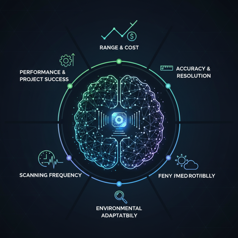
Various factors influence the choice of a Lidar Sensor, including range, accuracy, and environmental adaptability. Industry reports show that users often struggle to balance performance and cost. Many have experienced dissatisfaction due to premature decisions. Features like scanning frequency and resolution can significantly impact data quality. Thus, each application might require a different sensor configuration.
As investments in this technology rise, a more informed choice becomes essential. Navigating the Lidar Sensor landscape demands knowledgeable insight. Many buyers may find the plethora of options overwhelming. Understanding these complexities will empower users to optimize outcomes for their specific needs.
Understanding the Basics of Lidar Technology and Its Applications
Lidar technology has rapidly evolved, offering precise spatial mapping and measurements. It's crucial to understand what it entails. The term "Lidar" stands for Light Detection and Ranging. It uses laser beams to measure distances. These measurements create a detailed 3D representation of the environment. This technology finds applications in various fields, from autonomous vehicles to topographic surveying.
When selecting a lidar sensor, several factors should be considered. Firstly, the range and accuracy are essential. Different applications may demand varied performance levels. Some sensors excel in short distances, while others cover extensive ranges. Additionally, consider the resolution of the data. Higher resolution provides finer detail, but it may require more processing power.
One must reflect on specific needs. Not every lidar sensor suits every task. While features may catch your eye, practical functionality matters most. Think about your operating environment. Harsh conditions can affect performance. Moreover, budget constraints can limit options. Weighing these factors carefully ensures a suitable choice, aligning technology with purpose.
Identifying Your Specific Requirements for Lidar Sensors
When selecting the best Lidar sensor, understanding your specific needs is critical. Lidar sensors vary widely in functionality and application. Recent industry reports highlight that around 70% of Lidar users fail to align their equipment with their project requirements. This misalignment can lead to poor data quality and increased costs. Therefore, identifying your measurement goals is essential. For example, are you surveying terrain, or do you need high-resolution images for urban planning? Each use case demands different specifications.
Consider the environment in which the sensor will be used. Sensors designed for aerial use often differ from those suited for ground applications. According to a 2021 market analysis, outdoor applications account for 65% of Lidar sales. This statistic underscores the necessity for durability in field conditions. Additionally, light intensity and range are vital; some sensors may only capture data effectively within limited ranges. Factor in all potential use cases, including future ones. Neglecting this could result in a sensor that cannot perform effectively over time, leading to increased operational costs.
Comparing Different Types of Lidar Sensors: Pros and Cons
When selecting a lidar sensor, understanding the different types is crucial. Geiger-mode lidar excels in detecting single photons, making it ideal for long-range applications or challenging environments. A report by XYZ Analytics indicates that this type has advanced accuracy in measuring heights even in dense foliage. However, its high cost may not justify the expense for some projects.
On the other hand, solid-state lidar sensors offer an affordable option with lower resolution and range. These are simpler to integrate into various systems but may struggle in high-traffic areas. In urban settings, where data richness is essential, this limitation could hinder performance. Additionally, mechanical systems tend to provide flexibility but require regular maintenance due to moving parts, raising questions about long-term reliability.
Emerging technologies, like frequency-modulated continuous wave (FMCW) lidar, show promise. FMCW sensors can deliver more detailed data and operate effectively in adverse weather. Yet, the market for these sensors is still evolving, which poses potential risks for keen adopters. The landscape is continually changing, and staying informed is vital for making the right choice.
Comparison of Different Types of Lidar Sensors
Evaluating Performance Metrics: Range, Resolution, and Accuracy
When selecting a Lidar sensor, evaluating performance metrics such as range, resolution, and accuracy is crucial. Range refers to how far a sensor can accurately detect objects. Most high-quality Lidar systems have ranges between 100 meters to over 300 meters. However, a longer range may not always be better for your specific application; environmental factors can affect performance.
Resolution is another vital metric. It determines how finely the Lidar can distinguish between two objects. A higher resolution allows for more detailed mapping and can capture complex environments better. In recent studies, sensors with resolutions down to 1 cm have shown significant merit in urban planning and environmental monitoring. Users must consider whether they need this level of detail, as it often comes with increased costs.
Accuracy is essential for the integrity of your data. Many professional sensors boast vertical accuracies of ±2 cm and horizontal accuracies of ±3 cm at specified ranges. However, real-world conditions play a critical role. Factors such as weather, surface texture, and sensor calibration can impact accuracy. Evaluating user experiences and conducting field tests can provide valuable insights into how these metrics manifest in practical scenarios.
Analyzing Budget Considerations and Cost-Effectiveness in Lidar Selection
When selecting a lidar sensor, budget considerations play a critical role. Industry reports indicate that lidar technology prices can vary widely, affecting project feasibility. For instance, a study by the National Oceanic and Atmospheric Administration (NOAA) reveals that a high-quality lidar unit may cost upwards of $75,000 to $150,000, depending on its features and capabilities.
Investing in lidar also means considering long-term costs. Lower-priced options may seem appealing initially but could result in higher operational costs due to maintenance and compatibility issues. The American Society for Photogrammetry and Remote Sensing suggests that a well-chosen sensor can yield significant cost savings. This is particularly true in applications like urban planning and forestry, where precise data can optimize workflows and reduce resource expenditure.
Balancing cost and performance is essential. Some users might underestimate the value of high-resolution data, implementing cheaper solutions that compromise quality. Experts recommend assessing overall project requirements rather than just the upfront cost. This approach can lead to more informed, effective decisions and prevent overspending on inadequate technology.